MarineWaysBoatingistheultimatemarinenavigationandplanningapplication!Inthisapplicationyouwillgainaccessto:
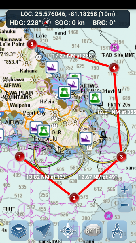
FREENAVIGATIONALCHARTS
-UnitedStateschartsprovidedbyNationalOceanicandAtmosphericAdministration(NOAA)
-NewZealandchartsprovidedbyLandInformationNewZealand(LINZ)
Charttypes:
-NOAAElectronicNavigationalCharts(ENC)(NOAA'snewestandmostpowerfulelectronicchartingproduct).
-NOAAclassiccharts(includingDay,Red,Dusk,Night,andGrayversions).
-LINZcharts(availableinDay,Dusk,andNightversionsonlycurrently)
ROUTEPLANNINGTOOLS
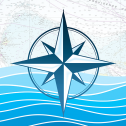
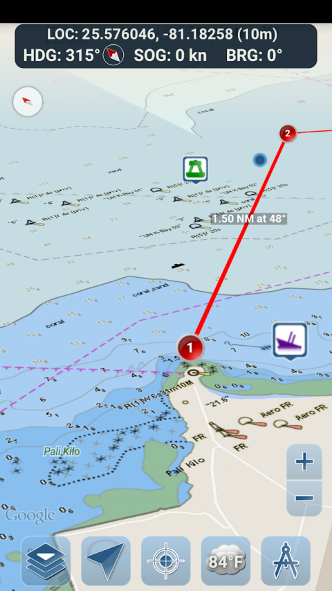
-RoutePlotting.Tapandholdonthemapforonesecondtoplotyourwaypoints.Toformaroute,continuetotapandholdonthemapindifferentareas.Distanceandbearingareconvenientlycalculatedanddisplayedforeachlegasyouadd,adjust,orremovewaypoints.
-TravelMode.Automaticallycentersthemaponyourcurrentpositionasyoumove.Usetravelmodetoseehowcloselyyouarefollowingyourplottedrouteinrealtime!
-RouteLegSummary.Aconvenientviewcontainingdetailedinformationofeachlegyouhaveplotted,includingstartandendcoordinates,distance,andbearing.
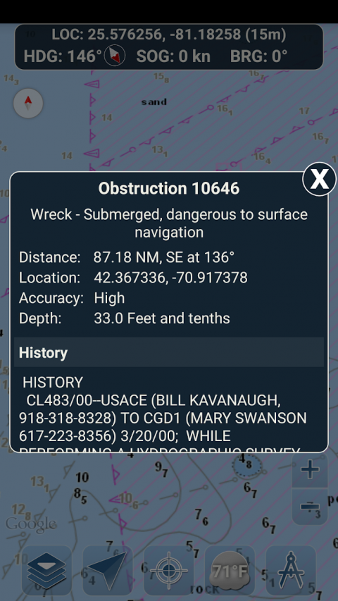
BUOYREPORTSANDOBSTRUCTIONINFORMATION
Markersforbuoysandobstructionsareconvenientlyplottedintheiractuallocationonthemap!Justclickonthemarkertoviewtheirinformation!
-BuoyReports:Getcompletecurrentconditionsandwavereportsforfixedanddriftingbuoys.
-Obstructions:Getlocationandhistoryinformationaboutpotentiallydangerous,submergedhazardsincludingrocksandsunkenvessels.
NAVIGATIONDASHBOARD
Thenavigationaldashboardshowsvariousreal-timeinformationincluding:
-Currentlocation(latitudeandlongitude,withaccuracyrange)
-CurrentHeading(includesasmalldirectionalcompassaswell!)
-CurrentSpeedOverGround
-CurrentBearing
MARINEMAPOVERLAYS
Togglevariousmarineoverlaydatarightontothemaptogetabetterideaofthecurrentboatingconditions!
Overlaysinclude:
-WaterSurfaceTemperature(Global)
-WindSpeeds(USonly)
-WindGusts(USonly)
-WaveHeights(USonly)
LOCATIONSHARINGOVERWATER/VIEWOTHERBOATS
-Displayyourlastknownlocation,speed,bearing,andboatnameonthemapforotherMarineWaysboaterstoview.
-Viewthelastknownlocation,speed,bearing,andboatnameofotherMarineWaysboaters,aswellastheirdistanceandbearingfromyourlocation.
-Locationsharingisturnedoffbydefault.Whenyouarereadytoshare,toggleitonwithingeneralsettings.Tocontinuouslyupdateyourlocationonthemap,keeptheappopenedandfocused.Theappcurrentlydoesnotupdateyourlocationinthebackground.
WEATHERINFORMATION
-WeatherPrecipitationRadar(US&Hawaiionly).Detectsanyrainandsnowinthearea.
-WeatherStation.Reportsthenearestobservationstationdata.Currenttemperature,humidity,weatherconditions,wind,andmore!Stationobservationdataisavailableglobally.
-WeatherAlerts.WeatherstationalsoreportsanyactiveweatheralertsissuedbytheNationalWeatherServicesuchasseverethunderstormwarningsorhurricanewarnings.WeatheralertinformationisavailableforUS,AlaskaandHawaii.
-LandSurfaceTemperatureoverlay.Showsthecurrentsurfacetemperatureonland(USonly).
Beforeusingthisapplication,pleasereadandagreetothefollowingtermsofuse/serviceandprivacypolicy:
TermsofUse/Service:http://www.marineways.com/appterms
Privacypolicy:http://www.marineways.com/appprivacy
NavigationalChartsDisclaimerfromNOAA:
NOAAENCOnlineisnotcertifiedfornavigation.ScreencapturesoftheENCsdisplayedheredoNOTfulfillchartcarriagerequirementsforregulatedcommercialvesselsunderTitles33and46oftheCodeofFederalRegulations.
Enjoytheapp!MarineWaysisalsoavailableonthewebathttp://www.marineways.com
Show More
-
Marine Ways
1.24for Android
Arpeggio