EasytouseoutdoornavigationappwithmostrecenttopographicmapsofNewZealand,CookIslandsandTokelau.
ThisappgivesyousimilarmappingoptionsasyoumightknowfromGarminorMagellanGPShandhelds.
Mainfeaturesforoutdoor-navigation:
•CreateandeditWaypoints
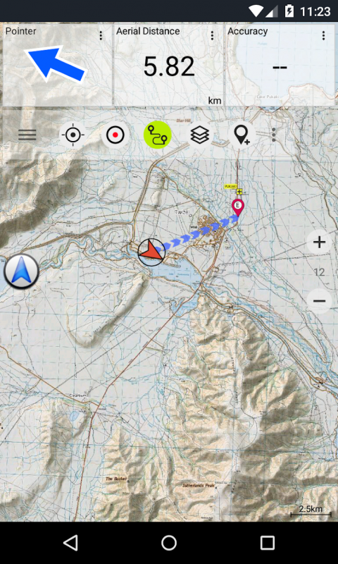
•GoTo-Waypoint-Navigation
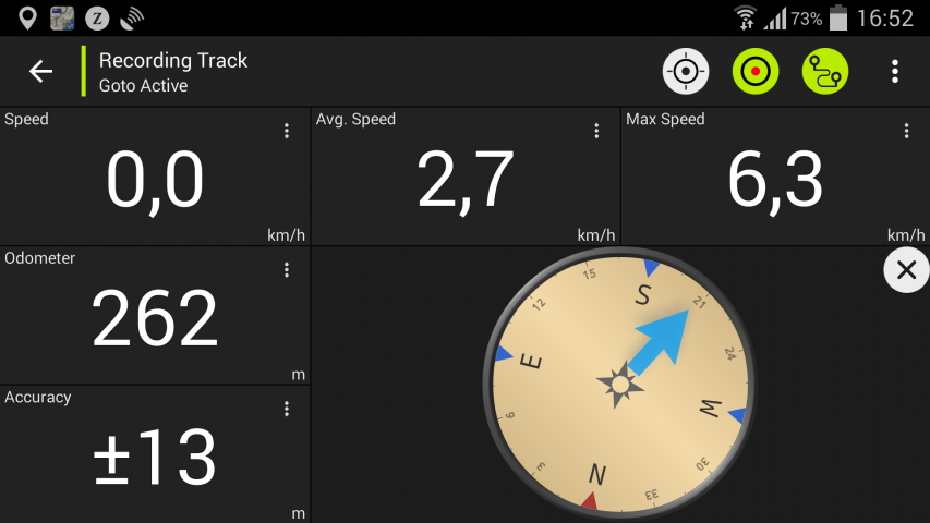
•TrackRecording(withspeed,elevationandaccuracyprofile)
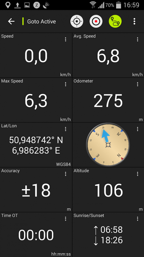
•Tripmasterwithfieldsforodometer,averagespeed,bearing,elevation,etc.
•GPX-Import/Export,KML-Export
•Search(placenames,POIs,streets)
•CustomizabledatafieldsinMapViewandTripmaster(e.g.Speed,Distance,Compass,...)
•ShareWaypoints,TracksorRoutes(viaeMail,Facebook,..)
•UseCoordinatesinUTM,WGS84orMGRS
•andmanymore...
Availablebasemaplayers:
•TopomapsNewZealand(seamlesscoverageatscales1:250.000and1:50.000)
•NZMariner(RNCNauticalCharts)
•LINZAerialImagery
•GoogleMaps(Satelliteimages,Road-andTerrain-Map)
•OpenStreetMaps
•BingMaps
•ESRIMaps
Overlaylayers:
•PublicConservationAreas
•OpenHuntingAreas
•DOCCampSites
•DOCFreedomCampingRestrictions
•DOCHuts
•DOCTRacks
•TaupoTroutFishingDistrict
•Hillshading
Usethisnavigationappforoutdooractivitieslikehiking,biking,camping,climbing,riding,skiing,canoeingoroffroad4WDtours.
PreloadFREEmapdataforareaswithoutcellservice.(Proversiononly)
LIMITATIONSOFTHEFREEVERSION:
•Ads
•Max.3Waypoints
•Max.3Tracks
•NoRoutes
•Noimportofwaypointsandtracks
•NoBulkdownload
•NoLocalCityDB(OfflineSearch)
ThetopographicmapswerecreatedbyLandInformationNewZealand(LINZ).
Topo50istheofficialtopographicmapseriesusedbyNewZealandemergencyservices.
Howtopographicinformationisused
Defenceplanning:NewZealand'sdefenceforcesusetopographicinformationforplanningmilitaryexercisesandswappinginformationwithinternationalpartners.
Locationandrouting:SearchandRescue,defence,ambulance,fireservice,policeandcivildefenceagenciesusetopographicinformationinawiderangeofplanningandoperationalsituations,fromnaturaldisasterstocommunitypolicing.Usagemayinvolvemobile/fieldandcontrolroomsituations,andthecombinationoftopographicinformationwithotherdata.
Landmanagement:Topographicinformationisusedbylocalgovernmentforregionalplanningandoperations,andbypower,gasandtelecommunicationscompanies.
Inaddition,LINZmapsareusedforagreatvarietyofpurposesbybusinessesandgovernmentdepartmentssuchastheDepartmentofConservation,andbyrecreationaluserssuchastrampersandtourists.
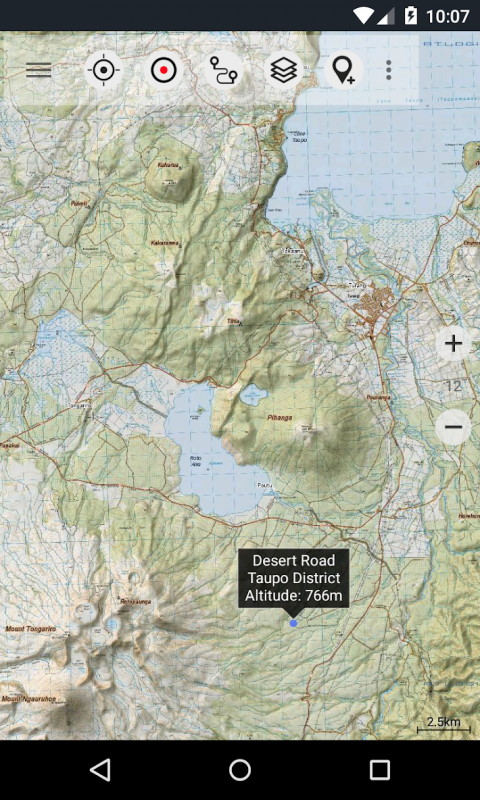
Alltopographicmapshaveadditionallabelsforbetterreadabilityathigherzoomscales.MapsarerenderedwithAtlogis®hillshadingtoenhancetopography.
TopoMapCoverage:
NewZealandandIslands(Antipodes,Auckland,Bounty,Campbell,Chatham,Kermadec,Raoul,SnaresandStewartIslands)atscale1:50.000and1:250.000
CookIslands(Aitutaki,Atiu,Mangaia,Manihiki,Mauke,Mitiaro,Palmerston,Penrhyn,Pukapuka,Rakahanga,Rarotonga,Suwarrow,Takute)atscale1:25.000
TokelauIslands(Atafu,Nukunonu,Fakaofo)atscale1:25.000
Pleasesendcommentsandfeaturerequeststonzmaps@atlogis.com
Show More
-
New Zealand Topo Maps Free
6.3.1for Android
ATLOGIS Geoinformatics GmbH & Co. KG