EasytouseoutdoornavigationappwithfreeaccesstothebesttopographicmapsandaerialimagesfortheUSA.
***PleaseuseUSGSNationalMaporOSMifyouneedmostrecentmaps***
Choosebetween>20maplayers(topos,aerials,seacharts,flightcharts,...)
TurnyourAndoidPhone/TabletintoanoutdoorGPSfortripsintothebackcountry.
ThisappgivesyousimilarmappingoptionsasyoumightknowfromGPShandhelds.
Mainfeaturesforoutdoor-navigation:
•DownloadofmaptilesforOFFLINEUSAGE(PRO-VERSIONONLY!)
•DisplayReal-TimenowCoastWeatherInformationandNEXRADWeatherRadar
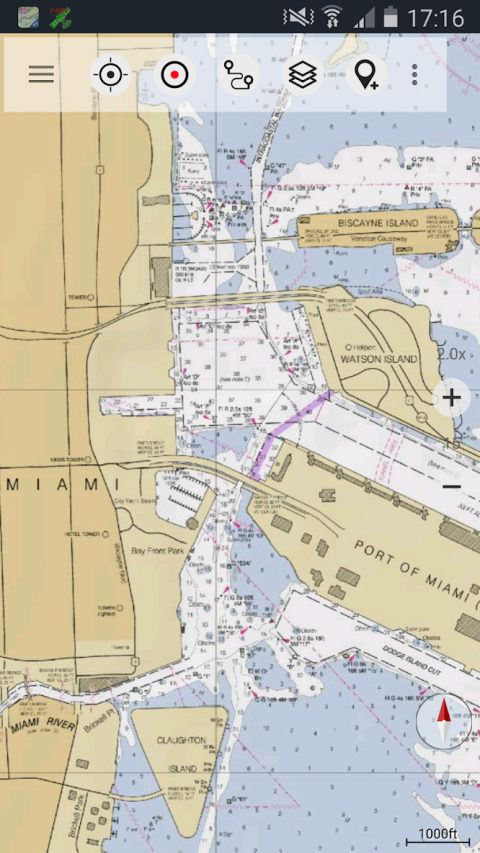
•Freeaccesstomorethan100.000seamlesslystitchedUSGStopographicmaps-easytouseasbrowsablemaplayer
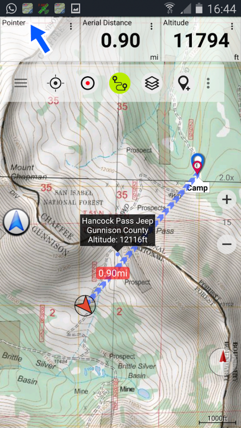
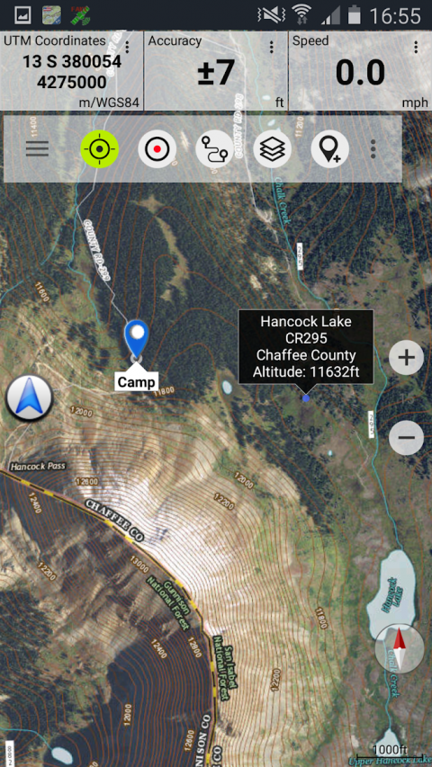
•CreateandeditWaypoints
•GoTo-Waypoint-Navigation
•CreateandeditRoutes(PROonly!)
•Route-Navigation(Point-to-PointNavigation)
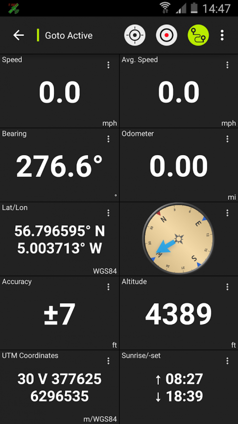
•TrackRecording(withspeed,elevationandaccuracyprofile)
•Tripmasterwithfieldsforodometer,averagespeed,bearing,elevation,etc.
•GPX/KML/KMZImport/Export
•Search(placenames,POIs,streets)
•CustomizabledatafieldsinMapViewandTripmaster(e.g.Speed,Distance,Compass,...)
•ShareWaypoints,TracksorRoutes(viaeMail,Dropbox,Facebook,..)
•UsecoordinatesinWGS84,UTMorMGRS/USNG(MilitaryGrid/USNationalGrid)
•GetNWSWeatherForecast
•TrackReplay
•andmanymore...
Availablemaplayers:
•USGSDRGs:SeamlesscoverageoftopomapsoftheUSAatScales1:250.000,1:100.000,1:63.000and1:24.000/25.000
•USGSHighResolutionaerialimagery
•USGSNationalMap
•OrthoimageryforconterminousUS
•GoogleMaps(Satelliteimages,Road-andTerrain-Map)
•BingMaps(Satelliteimages,Road-Map)
•OpenStreetMaps
•EarthAtNight
•FSTopoForestMaps
•NOAANauticalRNCCharts
•PublicLandOwnership(Padus)
•FlightCharts
Availablemapoverlays:
•HillshadingoverlaylayerforOSM,GoogleorBingmaps(PRO-VERSIONONLY!)
•RidgeWeatherRadarNWS
•Wind,Temperature,Pressure
•WindVectors
•PrecipitationEstimate-1-hr
•PrecipitationForecast24h
•SurfaceAirTemperature
•HazardWarnings
•TropicalCycloneTrack
•WindVectorForecast24h
•Max.AirForecast24h
•Min.AirForecast24h
USGSDRGtopographicmaps:
The7.5-minutemaps(1:24.000/1:25.000)arethebestmapsforoutdooractivitiesintheUSA.Althoughsomeofthemapsarequiteold,theycontainmanysmallpathesand4WDtracksthataremissinginnewUSTopos,Google,BingandOSMmaps.
NewUSTopoMaps:
USTopomapsareagraphicsynthesisofTheNationalMapdatafilesandareproducedinthefamiliar7.5-minuteby7.5-minutegeographicformat.CurrentUSTopomaplayersincludeanorthoimagebase,transportation,geographicnames,topographiccontours,boundaries,hydrographyandwoodlands.AlsoincludedarethePublicLandSurveySystem(PLSS)andtheUnitedStatesNationalGrid.
NAIPOrthoimagery:
SeamlesscoverageofcontiguousUSwith1m/pixelresolution
HROaerialimagery:
HighresolutionarialphotoscoveringUSurbanareas&borders(upto10cm/pixel)
Usethisnavigationappforoutdooractivitieslikehiking,biking,camping,climbing,riding,skiing,canoeing,hunting,snowmobiletours,offroad4WDtoursorsearch&rescue(SAR).
Addcustomwaypointsinlongitude/latitude,UTMorMGRS/USNGformatwithWGS84datum.
Import/Export/ShareGPS-Waypoints/Tracks/RoutesinGPXorGoogleEarthKML/KMZformat.(PRO-VERSIONONLY!)
ViewReal-timenowCoastweatherinformationliketemperatureorwindvectorsandoverlaytomap.
SeeanimatedNEXRADrainradartomakeaccuratepredictionswhenrainingwillstart/stop(PRO-VERSIONONLY!).
LIMITATIONSOFTHISFREEVERSION:
•Ads
•NoBulkdownload
•Nonew)US-Toposlayer
•NoHillshadingoverlay
•Max.3Waypoints
•Max.3Tracks
•NoRoutes
•Noimportofwaypointsandtracks
•NoLocalCityDB(OfflineSearch)
Pleasesendcommentsandfeaturerequeststousmaps@atlogis.com
Show More
-
US Topo Maps
6.3.0 freefor Android
ATLOGIS Geoinformatics GmbH & Co. KG