
FLYisFUNisdesignedbypilotsforpilots.FLYisFUNsimplifyflightpreparationandimprovesituationawarenessduringflight,providinginformationonairspaces,reportingpoints,positiononmovingmap,elevation,frequencies,railway,weatherinfo…facilitateaccesstoairfieldsrelatedPDFdocument.ApplicationalsodisplaysNOTAMsanddatafromrainfallradars.
FLYisFUNsimulatesILSapproach,VOR,NDB,DME,Markerbeacons,RNAVnavigationandMarkerbeaconswarnings,withoutILS/VOR/NDB/RNAVequipmentonboard.
YoucantestFLYisFUNforfreeduringfewdays.Attheendofthetrialperiod,pilotisinvitedtosubscribeandpayanannualfees.Doingit,hegettherightofusingtheapplication"asitis"andcontributetodevelopmenteffort.
FLYisFUNallows:
-Creatingandmodifyingroutesusing"draganddrop","rubberband"
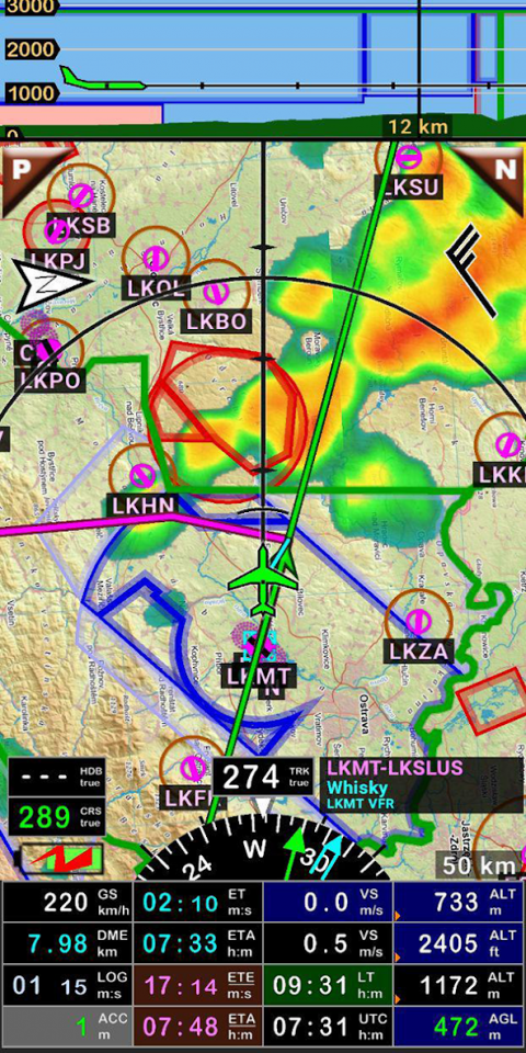
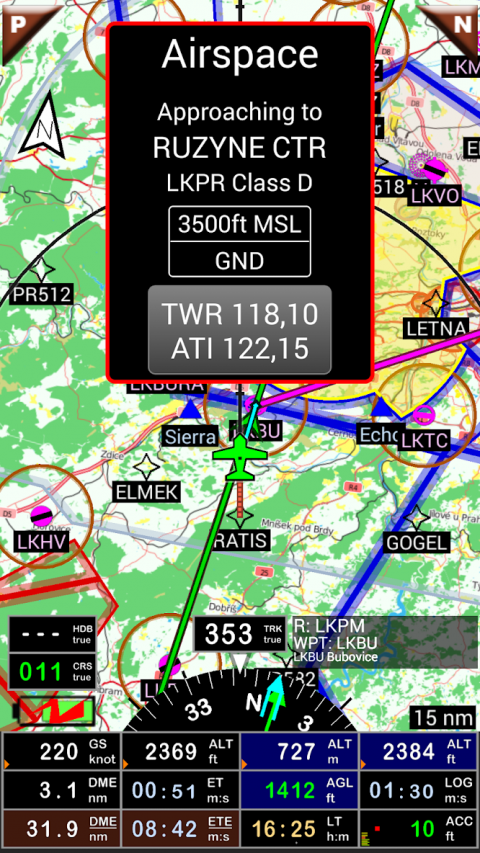
-Gettingwarnings,alarmsandradioinfobeforeenteringcontrolledorspecialuseairspaces,approachingpoints
-Performingrouteplanning,evaluatingdistance,timeandfuelconsumption(dependingonwindandaircraftcharacteristics)
-Displayingroute,bearing,traceonmovingmap
-Visualizingairspace
-Gettingdynamicterrainmap(colorsdependingofelevationabovegroundlevel)
-STRATUXsupport
-CreatingandexportingFlightPlan
-CreatingandexportingFlightlog
-Creating,importingorexportingroutes,waypoints,RWY,airspace(Garmin.gpx,.kml,txt,OpenAir)
-RecordingtheflightandplayingitbackwithGoogleEarth
-Sunset/Sunrise
-Gettingweatherforecastalongtheroute
-Rainfallradar
-Winddisplaying
-Calculatingdistancebetween2pointsonthemap
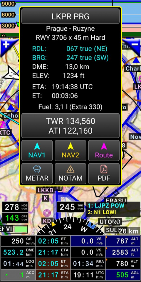
-VACs
-Notepad
…
Allmainscreens(5portraitand5landscapecouldeasilybecustomized.Pilotcanchoosefromaround100valuestodisplay.Example:
-AltitudeGPSorbarometric
-Groundspeed
-Bearing
-Verticalspeed
-DMEtonextpoint/destination
-Estimatedtimetonextpoint/destination
-Timesincedeparture
-Stopwatch
…
Displayedinformationcouldbecustomizedtoodependingofuserspreferences(VFR,IFRorboth)andzoomlevel.ThemoreyouzoomIN,themoredetail,information,waypoints,..yousee
Logbook
Theintegratedlogbook,allowsrecording:
-Durationsincedeparturetime
-Departureandarrivaltime
-Departureandarrivalairport
-Flighttrack(itispossibletoexportitas.kmlor.gpxandtoreplayit)
-Usedaircraft
-Pilot(s)andcopilotsincharge
-Distance,averagespeed,maximumspeed
…
NavigationdataavailablefromopensourcedatabaseareupdatedaccordingAIRACcycles.
Chartsandelevationdta
Freechartsandelevationdataareavailableformostofcountriesandcouldbeimporteddirectlyviatheapplicationstore.
Otherchartscouldbecreatedandimportedbythepilotitselformadeonrequestavailableascommercialservice.
Pilotscouldselectthemostappropriatecharts:freeopensourcechartsaswellascommercialchartsasICAO,Cartabossy,SkyVector,FAAsectionalandterminalcharts…
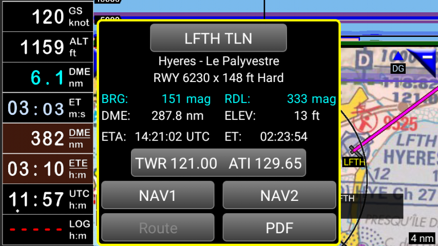
VACsandPDFfiles
VACandAIPinfosareavailableformorethan50countries
UsercaneasilyattachyourownPDFfiles.
UsageofexternalGPSconnectedviaBluetoothispossible
Userguide:http://www.funair.cz/downloads/manuals/flyisfun.pdf
Ifyouhaveanysuggestiontoimprovethisapplicationoryoufindsomebugpleasevisitwww.flyisfun.com
UsethisapplicationforVFRFLYINGONLY!!!Wearenotresponsibleforanyuseofthisapplication.
Show More

-
FLY is FUN
28.61for Android
Petr Kouril