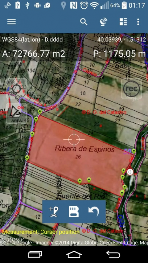
UseMapPadtocalculateareas,perimetersanddistances-save,exportandshareyourmeasurements.
MapPadisprovidingmulti-purposemappingsolutionallowinglocationcaptureanddeterminesdistanceandareafortheshapesdrawnonthemaporcapturedusingreal-timeGPStracking.
CalculateareaofthefieldorawalkdistanceinstantlyusingGoogleorBingMapSatelliteview.Savepetrolandtimeandcapturefeatureswithfewclicksonthemap.
Area&Distancemeasurementsareveryaccurate-pleasecomparewithotherappsandwhat'sontheground.
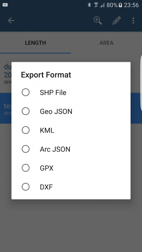
WithMapPadyoucancapture,manageandshareyourdataeasily.Appsupportsnumberofwell-knowncloudproviderslikeG-Drive,Dropboxandexportformats:SHPFile,GeoJSON,ArcJSON,KML,GPX,CSVandAutoCADDXF.
MapPadisaveryusefultoolforanyoneinvolvedinforestry,agriculture(measuringfarms,soils,grow,checkplantedareaetc.),roofing,solarpanelplanningandsolarpanelinstallation,fencing,construction,realestatemanagement,assetmanagement,wintersnowremovalorfarmingbusiness.
MapPadalsocanbeusedinthewholerangeofoutdooractivitieslikegolf(distancemeterandrangefinder),biking,walking,running,joggingandothersportswherepossibilityofmeasureareasordistancesisnecessary.
Pleasevisitourwebsitetofindouthowtoprepareofflinemapandgetmoreinformationaboutthisproduct.
Selectedfeatures:
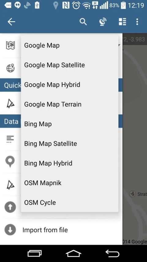
-Basemaps:GoogleMaps(Standard,Satellite,Hybrid,Terrain),OpenStreetMap(Mapnik,Cycle),BingMaps(Satellite,Hybrid,Roads).
-GoogleMapsOverlays(CustomWMSorArcGISServerTiledservice),somelayerslikeUSTopographicmaphavebeenpredefined.
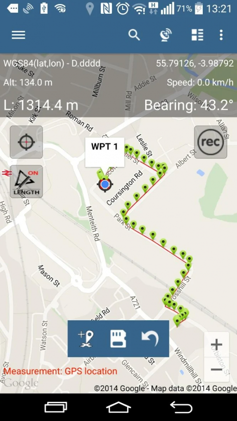
-Veryaccuratemeasurementofareasanddistances.
-3methodsofmeasurementaresupported(Taponthemap,GPSlocation,Mapcursorlocation).
-Supportfornumberofmetricandimperialunits.
-Supportforseveralglobalandlocalcoordinatesystems:WGS84(decimalordegrees),WebMercator,BritishNationalGrid,UTMSAD69(Brazil),UTMNAD83,NATO,Stereo70(Romania),System1992(Poland),GreekGrid–ifyourequiresupportforanyotherspatialreferencepleasegetintouch.
-Possibilitytocapturewaypointsandgroupthemincategories.
-Possibilitytoadd\edittitleanddescriptionforeachrecordedmeasurementandwaypoint.
-ExportsingleormultiplemeasurementsorwaypointstoSHPFile,GeoJSON,ArcJSON,KML,GPX,CSVandDXFtoSDCardorcloudserviceslikeFusionTables,DropboxorDirectlytoOpenStreetMap.
-SharesinglewaypointlocationdirectlybySMS,E-mailorotherways.
-ElevationprofileavailableformeasurementsdonebyGPS.
-ImportofKMLandGPXfilestotheapplication.
-GPSstatusandsatellitesstatus.
-Address,locationsearch.
-QuickopenexportedKMLfilesinGoogleEarth
-Abilitytosetdefaultmeasurementunits,waypoints'categoriescolours,trackrecordingtimeanddistanceinterval,transparencyofGoogleMapsoverlaysandmuchmore...
Pleasenote:
Ifyouexperienceanyproblemsorhavenewideasorcommentspleasedonothesitatetocontactusdirectlyorusingthecontactformsprovidedonourwebsite.Wetakeyouropinionveryseriouslyanddoappreciateanyformoffeedback.
OurusersaresuccessfullyusingMapPadinnumberofapplicationsincluding:
-environmentalsurveys,
-roofingandsolarpanelplanning,
-calculationsforsnowremoval,
-bikingandwalkingroutesplanning,
-forestryplanningandwoodlandmanagement,
-agricultureandsoils'surveys,
-roadconstructions,
-treesurveys
Show More
-
Map Pad GPS Land Surveys & Measurements
7.5.0for Android
Mapit GIS LTD