

FinalistoftheDATATON2018awards,organizedbytheNationalGeographicInstituteandtheHigherTechnicalSchoolofSurveying,CartographyandGeodesyEngineers.
Youmustactivatethe"HighPrecision"modefromyourdevice:SETTINGS-LOCATION-MODE.
Inorderforthelatestversiontoworkproperly,youmustCOMPLETELYUNINSTALLtheversioncurrentlyinstalledonthedevice.
UsefulandpracticalGPSwiththebestfeaturesyoucanfind:
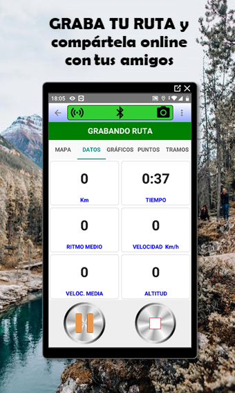
-ROUTES:Ifyoumakerunning,cyclingorsomeothersportyoucanstoretherouteyouhavemade,afterviewitonamap,showingtoyou:starttime,endtime,duration,distance,averagespeed,maximumspeed,Minutesperkm,maximumandminimumaltitude,timeatrestandtimeinmovement,etc.
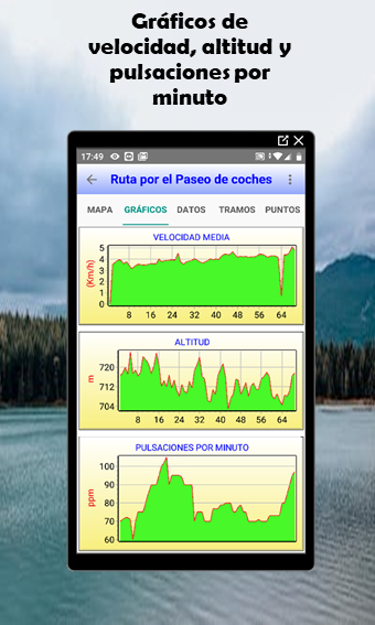
Itshows3Dgraphics(altitudeandspeed).
Colorizetherouteaccordingthespeed.
ExportroutestoformatGPXandKML.
-STATISTICS.Bytypeofvehicle,month.Itshowstimeofseveralpartsofeachroute.
-MEASURES:Youcanmeasurelengthoftheroutetouchingthemap,alsoyoucanmeasureareastouchingthemap.
-SATELLITES:ReportsthenumberofsatellitesusedbyGPS(withindicationofsatellitesignalstrength,azimuth,elevationandcountryoforigin)
Itshowsinagraphhowthesignalstrengthofeachsatellitechangeovertime.
-GPSDATA:Inapanelshows:latitude,longitude,speed,distance,acceleration,heading,altitudeandairpressure.
-MAPS:Itshowswithamarkeryourpositioninamap.
-POINTSOFINTEREST:Storeallthepointsofinterestthatyouneed(coordinates,description,altitude,markertype,etc.).
-ALTIMETER:Getsthealtitudeof3ways:searchingGoogleMaps,searchingtothealtitudedataoftheGPSandmeasuringthevariationoftheatmosphericpressure.
-COMPASS:whichinformsthecourseandthemagneticfield.
-GEOREVERSE:(Startingfromagivenlatitudeandlongitudeyougetthestreet,thenumber,theneighborhood,thecity,etc...)
-SUNPARAMETERS:Itshowsthetimeofsunrise,sunset,noon,minutesoflight,zenith,azimuth,elevationandsolardeclineforeveryminuteofthedaywithperpetualcalendar.
-SENSORS:Itshowsallthesensorsdevice.
Show More

-
GPS TOTAL RUN
2.0.24for Android
Javier Pareja