
ThisMarineChartsAppoffersofflinenauticalcharts,inlandrivernavigationcharts,andlakecontourmapsforkayaking,yachting&sailing.
FirstmarinenavigationapptohaveboatrouteassistancewithVoicePrompts.AllfeaturesofaMarineChartplotterinoneapp!
ItsupportsNauticalChartscourseuporientation.InclTideCharts&Currentspredictionfornauticalnavigation.
Createnewboatroutes/Waypoints,orimportexistingGPX/KMLroutesondevice.HasMarineAIS(NMEA)support.
►FEATURES
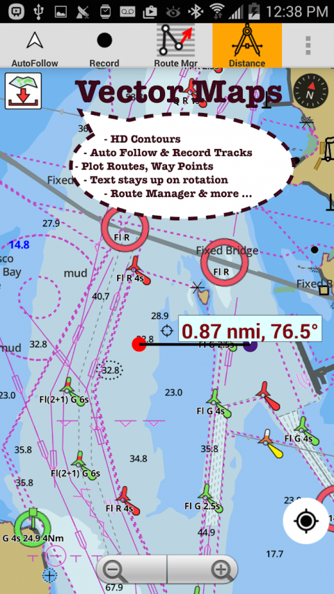
√GPUacceleratedofflinevectorNOAAcharts/ENCcharts(textstaysuprightonrotation)
√Lakedepthmapshading/safetylakedepthcontours:customizeboatsafetydepth
√MaritimeAidstoBoatNavigation:Beacons,Buoys,BoatLaunchareas,BoatRamps,Marina,FishingAttractorsetc
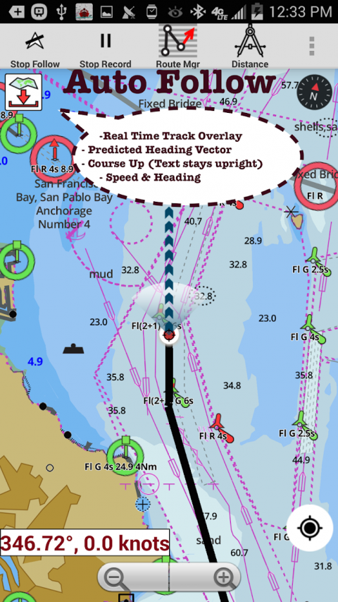
√Recordmarinetracks,Autofollowwithreal-timetrackoverlay
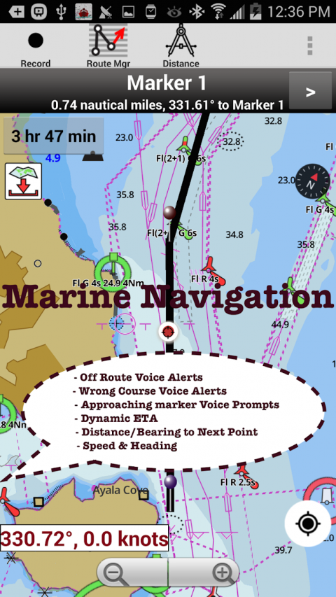
√VoicePromptsformarinenavigation
√HD1ft/3ftdepthlakecontourmapsforanglersforselectedlakemaps:forfishing/trolling(freshwater/saltwater).
√GPX/KMLforboatroute.
√Seamlessmarinechartquilting:DetailsfromCoastal,Approaches,Harbour&InlandENC(ElectronicMarineCharts)
√Waypoints
√Tide&Currents.
√MarineAIS
►MAPS
Alldetailsofyourmarinechartplotters!
Unlimitedupdatesfor1year.
USA:MapsinclcoverageofallNOAAmarinecharts,ENC,USACEinlandrivermaps&freshwaterlakebathymetrymapsformorethan20Klakes.ChartsinclHD/1ft/3ftbathymetryforselectedlakes.InclNOAAmarinecharts(rasters)whereNOAAENCcoverageisn'tavailable.
Canada:CHSdataInclGreatlakes(US&Canadasides),Alberta&Ontariolakes,LakeSimcoe&TrentSevernCanal,Quebecreservoirs.
UK/Ireland:UKHOmarinecharts
Germany:BSHcharts,Waterways&rivers.
France
EuropeInlandRivers:Donau/Danube/Dunaja,Rhine,Rhein,Garonne,Moselle,Drava,Sava
Australia
Netherland/Holland
Croatia
Finland
Norway
Sweden
Russia
Ukraine(BlackSea)
Brazil
Spain
Malta,Cypress&MediterraneanSea
Caribbean
NewZealand
Denmark,Greenland,Faroe
Seychelles,Mauritius,Tanzania
Falklands
Malaysia,SouthChinaSea
Persian/ArabianGulf,RedSea
SouthAfrica
Argentina
Iceland
Fiji
Estonia,Latvia,Poland,Lithuania
Turkey,Greece,Italy
►Instrumentation
√MarineAIS&(NMEAAISandGPSoverTCP/UDP)
√Winddirection&Speed,MarineSonardepth,Watertemperature
►ROUTEMANAGEMENT/TRIPPLANNING
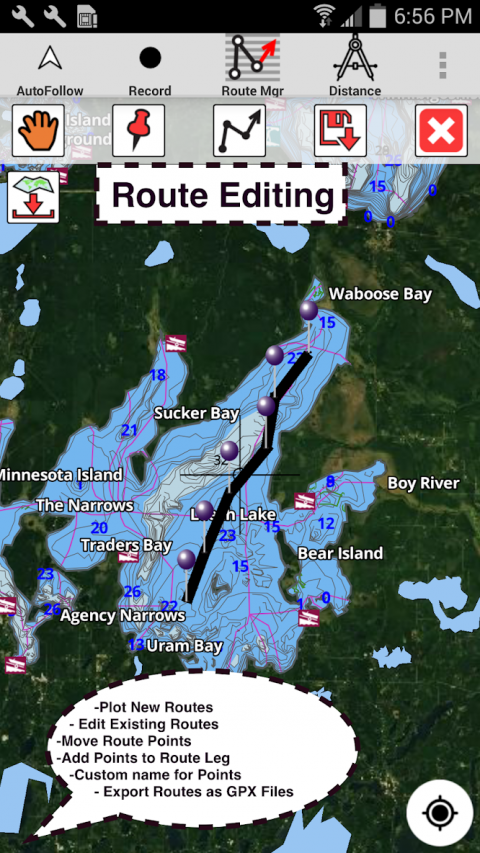
√Create/Edit/ReverseBoatRoutes
√Waypointsmgt
√ImportGPX,KML&KMZfiles
√Share/ExportRoutes,Boatinglog,Tracks&Markers
►FEATURESforBOATNAVIGATION
√AutoFollow
*RealTimeOverlay&PredictedPathVector
*CourseUp
*Speed&Heading
√RouteAssistanceWithVoicePrompts
*approachingboatingroutemarkerprompt
*Realtimenauticaldistance&ETA
*sailing/boatingoffroute/wrongdirection
√RecordTracks
►TIDE&CURRENTS
*High/LowTides
*TidalCurrentPrediction
*ActiveCurrentStations
►SHARING
*Sharingoftracks/Boatroutes/markers/Waypoints
*ExportGPXfiles.
►ChangebackgroundtoSatelliteImagery
►USAMarineCharts
*TexasLakes:Texoma,Eufaula,ToledoBend
*CaliforniaLakes:Tahoe,Shasta
*PennsylvaniaLakes:LakeRaystown
*FloridaLakes:LakeOkeechobee,Kissimmee
*MinnesotaLakes:LakeMinnetonka,Waconia,Leech,MilleLacs
*MassachussetslakesQuabbin
*MissouriLakes:Truman
*OhioLakemapsofLakehoover
*WisconsinLakes:LakeWinnebago,Pepin
*UtahLakePowell,Bear
*MaineLakeSebago
*AlaskaLakes:LakeWinnipesaukee
*TennesseeLakeBarkley,Norris,WattsBar
*SouthCarolinaLakeKeowee,Hartwell,Murray
*LakeMichigan,Huron,Ontario,Superior,Erie
►CanadaLakesMaps
*LacSaintJean
*LakedepthmapsofOntarioLakes
*RideauCanal-OttawaRiver
*BritishColumbiaMarineCharts
*PacificCoast-Vancouver-HaidaGwaii
*NovaScotiaSouth-BayofFundy
*QuebectoAnticostiIsland
*Newfoundland
*St.Lawrenceriver
*Manitoba&Saskatchewan
*GeorgianBay
*PugetSound
►UKNauticalCharts
*Scotland
*ThamesEstuary
*Ireland
►AustraliaMarineChars&LakeMaps
*NSW
*Queensland
Show More
-
i-Boating
190.0for Android
Gps Nautical Charts